Satellite Map Oddity

I got an email from Mike Scofield asking about this odd thing that can be seen via Google's satellite map out in the middle of the desert around Nevada. Mike writes:

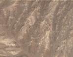
Assuming I did the link right, you should see a giant triangle with concentric circles in it. I did some poking around and it looks like this symbol is ~near~ Area 51. This leads me to think it's one of two different hoaxes. One is that it's a very good photoshop someone slipped into the satalite map that Google is referencing or, two, that it is a symbol out there in the desert someone did that isn't related to Area 51.

Honestly, I don't know what this is. I'm guessing it's some kind of military base. If you zoom in you can see that it hasn't been photoshopped in (at least, it doesn't appear to me as if it's been photoshopped). The triangle and concentric circles appear to be roads.
image

Photos Places

Posted on Tue May 10, 2005


Comments

I was looking around terraserver.com and found this image which clearly shows the "roads" as well... Check it out! 😊 http://terraserver.com/imagery/image_gx.asp?cpx=-116.027856&cpy=37.66692&res=8&provider_id=320&t=pan
Posted by AlmostAMAZING  on  Wed May 11, 2005  at  06:21 PM
FYI, Clicking the link in my last post doesn't seem to be working but if you copy past the url into a browser, that works...
Posted by AlmostAMAZING  on  Wed May 11, 2005  at  06:27 PM
god your all sooo naive, its not aliens or a bomb test site, it is obvously the esoteric prision for azathoth, dark lord of the universe whom has been imprisoned by the illuminati and being used as a power battery for their evil deeds... its obvous....

wheres my medication?
Posted by joeodd*FNORD*  on  Thu May 12, 2005  at  04:40 AM
David said, "if it is a gridline layout to measure explosive effects, why oblongs instead of perfect circles?"

I suspect that if you did the math, you'd find that they are perfect circles after you remove the effects of their being displayed on a cylindrical projection with a base latitude of 39.5 degrees.
Posted by Ron  on  Thu May 12, 2005  at  10:24 AM
http://maps.google.ca/maps?q=groom+lake&ll=37.401001,-116.868492&sll=34.710938,-112.109525&spn=0.007682,0.009946&sspn=3.851563,7.259440&t=k&hl=en

what do you make of this its like a cricle with lines coming out at the sides, isnt it weird what the government has put all over the south west
Posted by Hawkeye  on  Fri May 13, 2005  at  11:11 AM
Sure looks photoshopped to me.

There couldn't actually be straight lines across contoured terrain that look straight from more than one vantage point.

Here's a sample with some lines I added.


What makes you say it doesn't appear to be photoshopped?

Joe
Posted by joe  on  Fri May 13, 2005  at  12:26 PM
There is a process called "orthorectification" that attempts to correct for distortions caused by the limitations of the camera's optical system and by differences in elevation. It doesn't work very well on skyscrapers, but hills aren't generally a big challenge for the software. Depending on the source of that part of Google's image database, they might very well have been orthorectified at some point, thus making the lines straight again.
Posted by Ron  on  Fri May 13, 2005  at  12:31 PM
If it's a conspiracy or a photoshop job, someone at USGS was in on it, way back whenever the topo for that quad was revised (or when it was scanned for the DRG, which was more recently but still a while ago):

http://terraserver.homeadvisor.msn.com/image.aspx?T=2&S=12&Z=11&X=732&Y=5211&W=3
Posted by Ron  on  Fri May 13, 2005  at  12:53 PM
And of course my link doesn't work.

http://tinyurl.com/dleow
Posted by Ron  on  Fri May 13, 2005  at  01:18 PM
That's nothing. There are three patterns out in the desert around Phoenix that look like that. Here's a link to one of them. The others aren't too hard to find by yourself.
Posted by Tim  on  Thu May 19, 2005  at  12:38 PM
Oops, the link didn't come through in my post above so here it is.
http://maps.google.com/maps?ll=33.745537,-112.633896&spn=0.031328,0.042272&t=k&hl=en
Posted by Tim  on  Thu May 19, 2005  at  12:40 PM
that is near the Yuuca Mountain where they store nuclear waste. It might be some sort of protection
Posted by Pat  on  Tue May 24, 2005  at  07:16 AM
I found a giant metallic disk shaped object..
http://maps.google.com/maps?ll=33.745537,-112.633896
Posted by n----i0  on  Wed May 25, 2005  at  09:40 PM
The "Star of David" one is likely to be a bombing target simulation as well, since the Soviets would protect their nuclear missle launch sites with several SA-2 rockets laid out in that configuration.

During the Cuban Missle Crisis, U-2 recon photos showed locations just like those being prepared during the build-up.
Posted by Sybaris  on  Thu May 26, 2005  at  12:13 PM
what is this?

http://maps.google.com/maps?ll=37.410250,-116.226833

Its way north (about 3 minutes of clicking to get there) from the triangle
Posted by nik  on  Sun Jul 03, 2005  at  04:39 PM
http://maps.google.com/maps?ll=39.696865,-115.961208&spn=0.104859,0.161448&t=k&hl=en

I ment that... whats that?? circle things...O.o

(stupid copy didn't get what I wanted before)
Posted by nik  on  Sun Jul 03, 2005  at  05:27 PM
i think the circle things that nik is talking about are farm fields. the reason they're circular is because they have a sprinkler in the center that spins, causing the circle. as to why they're laid out the way they are (scattered everywhere), i don't know.
Posted by guy  on  Thu Jul 14, 2005  at  05:48 AM
That triangle thing in Nevada is supposedly a target with the #3 on it... there is a similar one if you go a bit to the west with a #2 on it... I have yet to find #1.

it is strange to see that unmarked airstrip... there are several in the area. The one that has been linked here, however, has an airplane sitting on the runway.
Posted by Thnikkamax  on  Mon Jul 18, 2005  at  01:25 AM
The triangle with circles in it are on (or nearby) the Nellis Air Force Range (NAFR). See the links below for more information. This test range covers 3 million acres.

http://www.globalsecurity.org/military/facility/nellis-range.htm
http://www.ufomind.com/area51/org/nellis/
Posted by Dave  on  Thu Aug 18, 2005  at  09:04 AM
I think this is a target out at the test range in nevada. I could be wrong but that is what it looks like, go to the atomic museum web page, I think that is where i saw it the first time.
Posted by lance scott  on  Sat Sep 03, 2005  at  01:52 AM
Enough with the conspiracy theories! They don't call this region of Nevada a "bombing range" for nothing. Though I'm sure there are some secretive things going on, everything posted here so far is a legitimate part of the bombing range. These are targets, mock air strips, etc., and are intended to be blown up. The large craters are indeed caused by nuclear weapons tests. The small craters all over the rest of the range are traditional bombs.

Much of the bombing range is accessible to the public and/or the media, though you usually need a guide (for your safety).

The big triangle is an old gravel air strip, with runways in three directions to facilitate unpowered landings in just about any wind.

The green circles are irrigated agriculture and are OUTSIDE of the bombing range. In Google, the area reserved for the test site is marked in gray, just like all government land or national parks.

These are not pranks or secret government installations. They're things you should expect to see on a bombing range/nuclear test site.
Posted by David  on  Sun Sep 25, 2005  at  08:30 PM
Did anyone ever find target #1? You only see #2 and #3 posted all over, but not #1.
Posted by Thnikkamax  on  Mon Sep 26, 2005  at  03:57 PM
Theres a similar area in Indiana. I've drove by it many times, big fence, warning signs, etc. Used to be a bombing area. Some areas are being/have been checked for live bombs and are being opened as an area for hunters and fishermen. Heres a funny pattern and an airstrip in this area. Pan around theres lots of stuff.

http://maps.google.com/maps?ll=37.666926,-116.027856&spn=0.015600,0.021286&t=k&hl=en
Posted by doug smiley  on  Sat Oct 01, 2005  at  09:58 PM
stupid link - try again:
<a >CLICK!</a>
Posted by doug smiley  on  Sat Oct 01, 2005  at  09:59 PM
why does it always go to the thing in the desert, hmm..

<a > this should work</a>
Posted by doug smiley  on  Sat Oct 01, 2005  at  10:01 PM
It's real, and was constructed at great expense by the church of scientology as some sort of a beacon to inter-stellar travellers to "guide them in".

Google it if you're interested.
Posted by Trevor  on  Sat Dec 31, 2005  at  02:11 AM
I see that same symbols in visions. The earth is not the only place where life grows. The triangle is a symbol of life, and the same symbol on th ships. They will come. 2012
Posted by The never telling  on  Wed Mar 08, 2006  at  11:53 PM
pratap (up) map
Posted by abhishek somvanshi  on  Wed Jul 19, 2006  at  09:34 AM
THis one is weird too
Posted by FRANKARDETTE  on  Sun Oct 22, 2006  at  02:56 PM
I'm Erandika Sandaruwan.From Sri lanka.
Posted by Erandika  on  Sat Dec 09, 2006  at  11:49 PM
Made by the US military during the cold war to distract the russians; hoping they would do the same as the people that replied: spending time finding out what it is......
Posted by Weps  on  Fri May 18, 2007  at  08:12 PM
guys, it's clear as daylight, it a bombing area. It is used for army exercices. look at this: http://mapper.acme.com/?lat=37.666905&long;=-116.02786&scale=12&theme=Topo&width=4&height=3&dot=Yes . On the Topo option, it says TARGET. and if you look closely in the middle of it you can actualy see 4 tanks and a lot of bomb holes.in the target area. That triangle was a target area that now is not used anymore( inactive target). So, no aliens, sorry.
Posted by Cruise  on  Fri Mar 12, 2010  at  09:14 AM
http://www.panoramio.com/photo/34836680#comment


There's photos from the "neighbourhood".
Posted by Edi from Finland  on  Fri Oct 29, 2010  at  12:55 PM
Comments: Page 1 of 2 pages  1 2 > 
Commenting is not available in this channel entry.