I got an email from Mike Scofield asking about this
odd thing that can be seen via Google's satellite map out in the middle of the desert around Nevada. Mike writes:
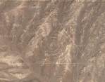
Assuming I did the link right, you should see a giant triangle with concentric circles in it. I did some poking around and it looks like this symbol is ~near~ Area 51. This leads me to think it's one of two different hoaxes. One is that it's a very good photoshop someone slipped into the satalite map that Google is referencing or, two, that it is a symbol out there in the desert someone did that isn't related to Area 51.
Honestly, I don't know what this is. I'm guessing it's some kind of military base. If you zoom in you can see that it hasn't been photoshopped in (at least, it doesn't appear to me as if it's been photoshopped). The triangle and concentric circles appear to be roads.


Comments
Although it does look like the roads in the lower left in color and width, those roads bend as they go over ridges and valleys, while the lines of triangle-and-circles do not, although the t&c lines do have color changes, when they go over the ridges, like the roads do. But they're arrow-straight on the monitor -- I held the side of a piece of paper up to my screen to check.
One *could* make a road which looks straight from the air, despite going over ridges, but it would result in some odd kinks and jinks in the actual road. I'll be interested to hear more on this.
http://mapper.acme.com/?lat=37.666905&long=-116.02786&scale=12&theme=Topo&width=4&height=3&dot=Yes
These markings almost certainly are not on the ground and have been added to the piccy. BTW how did Mike Scofield come across the markings?
Plus, if you look carefully you can see pock-mark craters from bombs inside and near the design.
this would suggest that the picture was taken from a southerly direction, which (i would expect) would cause the straight lines of the triangle to appear to be more distorted due to the terrain. since the lines aren't distorted, it suggests the picture is taken from directly above, which begs the question, if it is a gridline layout to measure explosive effects, why oblongs instead of perfect circles?
of course thats assuming the picture isnt digitally manipulated for copyrighting or 'other' purposes. government conspiracy? (i say in jest)
fascinating anyway.
http://maps.google.ca/maps?q=groom+lake&ll=37.401409,-116.867967&sll=34.710938,-112.109525&spn=0.004849,0.007467&sspn=3.851563,7.259440&t=k&hl=en
The rings don't merely tell you how accurate you were, they're roads so you can recover your dud, and the triangle makes it unmistakable, even for a rookie pilot. The triangle is a road, too, in case you miss the target by that far. The terrain is flat so that finding your bomb casing won't be too difficult, even if it's buried itself in the sand. Weather conditions are good for practise year-round. And there's nobody around to complain about bombing runs.
But it probably hasn't been used for training bomber crews for decades, at least since modern targeting technology became available. Someone who built bomb casings or trained there might remember that target even today, if you can find him or her.
Kat, I've seen things like that one when flying over the desert in commercial flights, too. That one is much more obviously an installation of some kind.
I like that explanation excpet it doesn't explain the backwards letter "E" at the top point of the triangle.
Maybe this is really an alien eye chart used for testing their space pilots before they issue flying licenses (point your tentacle in the direction you think the symbol is going).
I had a little spare time, so I tried to find the same area via the satellite images at terraserver. I didn't find any triangles, but that may only mean that I didn't find the right location. Somone with more time, or more familiarity with satellite images, may well succeed.
I was dragging the mouse around and lost the triangle. I looked for it again and I ran into that nearby. (Assuming I linked right as well) If you zoom in, you can see concentric circles. No triangle this time though. Guess it's not an isolated incident?
(For some reason you might have to change it to "sattelite" map, but just hit the zooms and it should still be centered in the right place)
http://tinyurl.com/85vp3
Here's the real URL, but the outgoing link is munged by museumofhoaxes, so it may not work properly if you click on it.
http://maps.google.com/maps?ll=34.954162,-117.873302&spn=0.018239,0.023603&t=k&hl=en
On the link posted by Nick, I zoomed out a little and found another group of concentric circles (to the North-West a little from his linked circles. In the center of the NW group of circles is what looks like a small building with a road linking the two circle groups.
If you go to the original triangle/circle group and zoom out to the fourth little pin from the top of the zoom bar then scroll south, you'll see that several of the things posted here are in this north-south corridor. This looks more and more like it fits the theory that these are bomb training tools and not maps for little green men to use as navigation tools.
Oh, and to answer how I found this: I'm a geek and found it on a gaming site.
~Mike
And
http://www.museumofhoaxes.com/hoax?URL=http://maps.google.com/maps?ll=37.404070,-116.237583&spn=0.021157,0.030770&t=k&hl=en
are probably normal stuff but seem strange to me. I'm odd.
http://www.museumofhoaxes.com/hoax?URL=http://maps.google.com/maps?ll=37.529469,-116.208959&spn=0.010579,0.015385&t=k&hl=en
Click me!
You'll have to zoom in and clink satelite of course.
So here's my input. They used to do aerial bombing runs, both post and pre hiroshima nuclear bomb being dropped. The idea was to hit a specific area with the nuclear payload and do a sharp 180 turn to get away from the blast as quick as possible. They look like drop zone targets to me, with a nearby airfield. This is probably where they train players who fly the steatlh bombers. Groom lake has been sited as a test grounds for stealth skunk work projects.
wheres my medication?
I suspect that if you did the math, you'd find that they are perfect circles after you remove the effects of their being displayed on a cylindrical projection with a base latitude of 39.5 degrees.
what do you make of this its like a cricle with lines coming out at the sides, isnt it weird what the government has put all over the south west
There couldn't actually be straight lines across contoured terrain that look straight from more than one vantage point.
Here's a sample with some lines I added.
What makes you say it doesn't appear to be photoshopped?
Joe
http://terraserver.homeadvisor.msn.com/image.aspx?T=2&S=12&Z=11&X=732&Y=5211&W=3
http://tinyurl.com/dleow
http://maps.google.com/maps?ll=33.745537,-112.633896&spn=0.031328,0.042272&t=k&hl=en
http://maps.google.com/maps?ll=33.745537,-112.633896
During the Cuban Missle Crisis, U-2 recon photos showed locations just like those being prepared during the build-up.
http://maps.google.com/maps?ll=37.410250,-116.226833
Its way north (about 3 minutes of clicking to get there) from the triangle
I ment that... whats that?? circle things...O.o
(stupid copy didn't get what I wanted before)
it is strange to see that unmarked airstrip... there are several in the area. The one that has been linked here, however, has an airplane sitting on the runway.
http://www.globalsecurity.org/military/facility/nellis-range.htm
http://www.ufomind.com/area51/org/nellis/